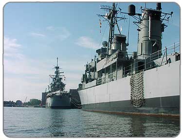
You can paddle next to the USS Sullivan and Little Rock on your way out to the Lake
PHOTOS
1
2
3
4
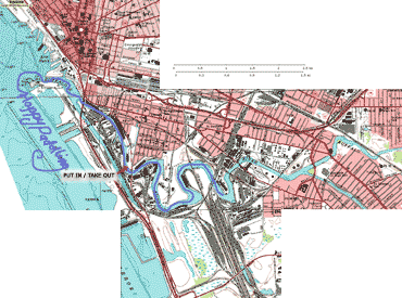
ROUTE MAP
Click on Map to Enlarge
|
Description:
The Buffalo river is part of the Buffalo River Urban Canoe Trail. There are a number of boat launch sites along the River. For this paddle, we launched at the Ohio Street Boat Launch (careful of the glass!) We met Gene on the water in his kayak emblazoned with a star. Gene is familiar with the Buffalo River and paddles it often, he said (don't be surprised if you see him out there sometime) The day was a hot day in July and the Miss Buffalo boat was making its tour through the area. We meandered down just beyond the train bridge, and turned around to retrace our paddle. Gene returned to the Ohio Street Boat Launch and we paddled out to play in Lake Erie, passing the enormous navy vessels, the USS Little Rock and the USS Sullivans.The Buffalo Lighthouse can be seen at it's best from the water, better yet at sunset on the water!
Put-in:
Ohio Street Boat Launch
between Ohio Street and Michigan Street Bridges next to Great Lakes Paper
Take out: same as put-in
Duration: Day Trip
Distance: The route we took covered about 4-5 miles
Portages: None
Loop Trip: No
Camping: No
LINKS:
WNYRIN- Buffalo River Urban Canoe Trail
Cornell Cooperative Extension - Map and sites along Buffalo River
NYS DEC- DEC owned boat launch sites
NYS DEC- DEC owned boat launch sites
|