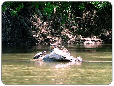
Turtles were around every bend. Some would let me get quite close to them, but as soon as they heard the motor from the camera, the photo opportunity was gone...
PHOTOS
1
2
3
4
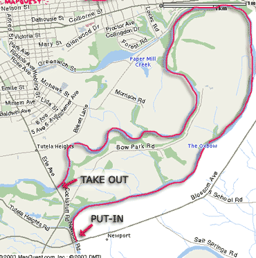
ROUTE MAP
Click on Map to Enlarge
|
Description:
The Grand River sounds ominous, and may be in parts, but this section was nice flatwater with a few swifts at the start to push you along nicely. I paddled this as only my second ever outing in my then-new kayak. And I was quite unprepared. And it was good to be humbled in the beginning, forcing me to learn some valuable lessons early on. I paddled this on a hot early summer day (I think it was early June, but it felt like mid-July) and made two mistakes: 1) I failed to bring enough water and 2) I thought I could paddle back to my starting point, up the strong swifts. Never underestimate the power of moving water (I was to learn this again later on in the season, but much closer to home).
This part of the Grand River is called the Oxbow, since it bends back on itself, forming a "U". This means that the end point is only about a mile from the starting point (as the crow flies), though you end up paddling almost 8 miles (as the river flows). It winds around some very nice countryside, including farms and fields of wildflowers.
I have never seen so many turtles in one place, ever. The only other place I've seen turtles is Oak Orchard River. Other wildlife I came across included herons, Canadian geese, ducks and even frogs. It was nice to see so much wildlife after spending much of the day on the QEW.
After arriving at the bridge (where I should have taken out and walked the less than a mile back to the car), I decided I'd try to return the way I came, since I wanted to get some more paddling in. For those pondering this option, let me just say "Forget it". Take out while you still can and think of the walk back to the car as some lower body exercise to finish off your total body workout.
There is a great description of this paddle trip online at Canadian Canoe Routes that I used as a guide for the trip.
Put in:
From the 403 coming from Hamilton - take the first exit at Brantford (Wendy`s / Tim Hortons exit) and head south towards Cainsville. Stay on Road 18 until you cross the Grand River at Newport Bridge and turn right at the first road. The first right is to the finish under Newport Bridge but if you continue north you`ll cross the Grand again. Immediately on the right is a dirt lane that leads to the water and is the starting point. You can park here, at your own risk, of course.
Take out:
1st Bridge is the takeout point (right side), Then walk 1500m back to the car to finish the loop
Facilities:
None. The town of Brantford is nearby, though, for food, restaurants and lodging.
Distance: About 8 miles, one way
Portages: Yes, about 1500m walk back to the car. At the bridge where you take out, you can leave your boat and chain and lock it to a tree, or bring separate vehicles to spot a car at each end if you don't want to walk back.
Loop Trip: No
Camping: No
LINKS:
Canadian Canoe Routes Information on this route
Grand River Conservation Area Good information on various aspects of the Grand River
Grand River Conservation Area Hamilton to Brantford bike trail
|