Tim Lake
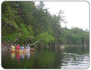
PHOTOS
1
2
3
4
5
6
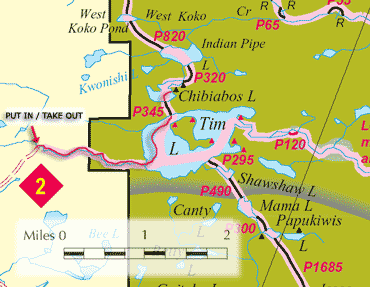
ROUTE MAP
Click on Map to Enlarge
 |
Description:
This trip to Algonquin Provincial Park was headed by Russ Crispell and Becky Doebler from UB's Outdoor Pursuits Club.
It was an amazing experience and I found it very difficult to return to "civilization" after 3 days co-existing with loons, bear and moose among the majestic pines and clear waters. If it had been any longer, I may have never returned.
We launched at access point 2, and began our journey down a very pretty stream surrounded by marshy wetlands. Then we canoed across big Tim Lake to a short mosquito-infested portage to Lake Chibiabos, where we set up camp (that little black triangle on the map was our campsite). The loons played a symphony for us each night and we were blessed to see wildlife every day of our trip.
I found an interesting description of "Chibiabos", which comes from the Potawatomi Nation, an American Indian nation from the woodlands or Great Lakes area of North America. Potawatomi believed that departed souls traveled to the west, beyond the sunset, and were assisted by Chibiabos, a mythological figure who guided them to heaven. Seems very appropriate for our temporarily "departed" souls.
We took a day trip on Saturday, which took us down a marshy area and through a beaver dam (or lodge?). A Mama Moose and her baby were feeding along the shore while we were out. She was very protective of her baby and would only let us get so close before she decided it was time to go.
On our departure on Sunday morning, a large moose took the time to bid us farewell from the parking area as we loaded up our van and returned home.
I highly recommend exploring some or all of these waters if you never have. Living among these landscapes for the three days I was there was something I will always treasure, and the company I had the privilege to travel with made the trip complete.
Put In:
Access Point 2
Take out:
Access Point 2
Facilities:
The closest one I know of is the Ranger Station.
Distance: From launch to campsite, just over 2 miles
Portages: 1, 345km long - see map
Loop Trip: No
Camping: Absolutely!
LINKS:
Algonquin Provinicial Park- Official site
Buffalo Outdoor Pursuits- Russ Crispell's organized adventures
Algonquin Outfitters- Rentals and wonderful in-depth info about Algonquin
Algonquin Park Map Online- 5MB pdf file!
|