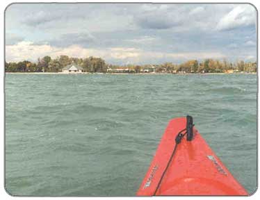
 Looking pretty choppy, here, sailor
PHOTOS
1
|
Description:
Canandaigua Lake is the fourth largest of the Finger Lakes and serves as the water supply for the communities of Canandaigua, Newark, Palmyra, Rushville and the township of Gorham. The northern end of the lake, bordered by the City of Canadaigua, is the most intensely developed area of the lake and the terrain is rather flat. However, as one paddles down the lake the cottages become fewer and far between, though albeit often bigger, and the terrain steepens quite significantly. The south end therefore tends to have less boat traffic, calmer waters, and is relatively more scenic. The maximum width of the lake is 1.5 miles and the maximum depth is 276 feet. All-in-all Canandaigua is nice clean lake to paddle and swim in during the summer and is a quick drive from Rochester.
Put-in:
ONTARIO COUNTY:
Canandaigua Lake State Marine Park, South Main St., Canandaigua, Off Rts. 5 & 20, N. end of Canandaigua Lake, Launch/Parking fee (summer only) = $5.
Adjacent to Route 21, three miles north of the Village of Naples. Concrete launching ramp. Parking for 80 cars and trailers.
On West Lake Road, 6 1/2 miles south of the City of Canandaigua. Concrete ramp. Parking for 25 cars and trailers. Restricted to winter launching, and then only when state park site at north end is unusable.
Canandaigua Outlet - On Latting Road 1/4 mile north of County Road 19. Hand launching. Parking for six cars.
Take out: It's up to you, really.
Duration: Day Trip
Distance: Length is 15.5 miles; 36 miles of shoreline.
Camping: Not that I'm aware of.
LINKS:
DEC info on Canandaigua Lake
|