 |
Starting Points |
|

|
|
Best Digital Collections |
 Perry-Castañeda Library (Univ. of Texas). Large collection of online maps and resources. Start on this contents page. Perry-Castañeda Library (Univ. of Texas). Large collection of online maps and resources. Start on this contents page.
- Current Interest Maps. When some place is in the news, this page provides maps related to the story.
- Historical Maps. Digitized historical maps, and links to world-wide historical map collections.
- National Map of the United States. Provides public access to high-quality geospatial data and information from multiple partners..
- National Geographic Maps. National Geographic map and atlas site. View or purchase maps of places worldwide. Includes: Country Profiles, Conservation Maps, Atlas updates, and more.
- World Factbook (Central Intelligence Agency). Annual World Fact Book. Information and maps for independent states, dependencies, areas of special sovereignty, uninhabitable regions, and oceans. Includes maps, statistical data, alerts, and other current data..
Digital Collections of Maps of Buffalo and WNY
These websites include: maps, aerial and satellite imagery, GIS, and a variety of other cartographic materials
|
|
Map Collections (Selection)
- William C. Wonders Map Collection (University of Alberta). Search digitized map database. Concentration on North American maps, but also has maps for all parts of the World. Good collections for: Western Canada, Northern Canada, Poland, Germany, France, and archival collections for Ukraine, British Isles, and Eastern Europe.
- Civil War Map Collections (Library of Congress American Memory).
- Jerusalem, Ancient
Maps of. Sample: Jerusalem [map]
by Nicolas, of Lyra, ca. 1270-1349. (Basel, 1498).
- Meteor Impact Craters. Select an impact site on the World map to locate satellite images and maps for that particular event. The Geology.com website also leads to maps and images of countries, geological maps of states, and more.
- Oil and Gas
- Roman Empire, Maps of the (Dalton School). Numerous maps and cartographic resources on the Empire, later Eastern and Western Empires. Also has links to items such as:
- La Maquette de Rome. Model of Rome as it was under Constantine in AD 320. Model is 180 x 180 cm, scale: 1:1,800. Very good detail allows you to take a virtual tour of ancient Rome.
- International Satellite Cloud Climatology Project (ISCCP). Has Cloud Data, Maps, And Plots.
- Gettysburg College Map Collection Search for maps then view/zoom in on map images.
- Sanborn Fire Insurance Maps.
Sanborn maps were produced for use by insurance providers but their wealth of detail makes them an excellent source for historians, planners, genealogists, and others looking for historic data or for studying the growth and development towns and cities. Their scale is 1 inch = 50 feet. The Digital Sanborn collection (UB Libraries subscription), covers, New York State from about 1895-1940s. Note: Not all cities and towns are covered. Check the index when you begin a session to see if a specific town is listed.
- See also: Map Collections. Many university and other collections.
|
Geography/Mapping Stuff You Can Use |
- Gazetteers Extensive list of most of the official or useful gazetteers on the web.
- Columbia Gazetteer (UB Libraries subscription database)
Comprehensive gazetteer, an encyclopedia of geographical places and features. Includes database of names, descriptions, and characteristics of over 165,000 places in the world. Search by type of place, place name or word search.
- Visited Countries Custom Map. Prepare a custom map of all the countries or states you have visited.
- Surface Distance Between Two Points
of Latitude and Longitude. Also has calculator for Great Circle measurements.
- FreeMapTools. A small variety of map tools for measuring and other functions.
- Geology.com map site. Maps and satellite images for World, Continents, Countries, etc. Click here for United States State Maps of each state. Many themes. Good for student papers, general maps. Select US Geology & Maps (left margin) to find a selection of maps for each state. Search Reference Maps for country maps and satellilte images.
- California Geographical Survey. "Exploring the world, one map at a time..." Includes: Electronic Map Library,
Wall Map Closet,
Mapping Resources.
|
Thematic and Other Maps (Selection)
Demographic Maps
- Examples of maps showing the same or similar data in different ways:
- Another example showing maps by specific theme:
- Global Health Observatory
Map Gallery (WHO). Worldwide maps.
- United States Census Geography (Bureau of the Census). Maps, GIS data, and other data relating to census.
- Global Health Observatory Map Gallery (World Health Organization). Statistical and other maps.
- Methamphetamine Addictions in the U.S. (National Institute on Drug Abuse (NIDA)).
- John Snow epidemiology maps (UCLA. Department of Epidemiology, School of Public Health). Site devoted to the life and times of Dr. John Snow (1813-1858), a legendary figure in the history of public health, epidemiology and anesthesiology. Maps of London before, during, and after Snow's work, especially on the 1854 Cholera epidemic. See the 1859 map.
- Malaria in Africa. From a Malaria Journal article.
- Mortality Maps for Texas (Texas Dept. of State Health Services). 1940 Standard Population 1970 Standard Population 2000 Standard Population.
- Poverty in the World. View maps, use GIS to visualize geospatial, poverty-related data, and the Atlas of Poverty.
- American Ethnic Geography: A Cultural Geography of the United States and Canada (Prof. Jon T. Kilpinen, Valparaiso University, geography course). Demographic maps showing U.S. (by county) for a variety of themes, including: Ethnic Groups, Culture Regions, Religion, Language, Politics, Socio-Economics.
- Humane Borders Water Station Maps And Warning Posters. Maps of the U.S.-Mexico border region, showing illegal immigration and water supply along the border.
- Death Penalty maps (Wikipedia Commons). This is an example of the types of maps available through the Wiki-world.
- Atlas of
United States
Mortality. (Centers for Disease Control and Prevention (CDC)). Example: Heart Disease map.
- Terrorist Attacks. World map showing locations.
- GEOFRED (Geographic Federal Reserve Economic Data,
Economic Research from the Federal Reserve Bank of St. Louis). Vital statistics for U.S. Available data for a wide-variety of topics.
- TOXMAP (U.S. EPA). GIS of data for on-site toxic releases and hazardous waste sites from the EPA's Toxics Release Inventory (TRI) and the Superfund National Priorities List (NPL).
- Historical Atlas of the Twentieth Century.
Maps, tables, and timelines on 20th century events. Includes a number of population and historical statistics themes, including:
agricultural, infant mortality, life expectancy, literacy, telephones, systems of government, and others (population, war).
Informal Demographic Studies (from Social Media, etc.)
Environmental Issues
The Pacific Gyres. The oceans filter a lot of waste material, however, many modern products cannot be broken down or absorbed. Materials such as plastics are not destroyed, but instead follow currents until they reach the various places where the currents circle, causing the materials to pile up. This is an environmental problem of massive proportions. The Pacific is featured here, but the Atlantic Ocean also has these regions.
- Trash vortex (Greenpeace International). Organization site describing the situation and what is needed to combat the piling garbage.
- Great Pacific Garbage Patch. Public organization that is raising awareness of the floating dump.
- Pacific Gyre is a website where science observes and studies this growing situation. Buoys drift with the currents, measuring and following garbage through its cycle.
Search the web for Pacific Gyres, or view several short articles:
News Maps
Smell Maps
|
|
Historical Maps
- David Rumsey Collection. Large worldwide collection of mostly pre-20th century political maps.
- Broer Map Library. Over 600 (and growing) collection of historical maps (1875+). The collection is searchable and zoomable and offers high-res image files upon request.
- Mapping History Project (Univ. of Oreg.) Historical and cultural maps of North America, Europe, with images.
- Chinese View of the World. The Jingban tianwen quantu was produced in the 1780s or early 90s by a Chinese scholar named Ma Junliang, who received the prestigious jinshi civil service examination degree in 1761. He was well-known for his skill as a mapmaker.
- Historical Maps Online (University of Illinois at Urbana-Champaign Libraries). Electronic images of maps charting 400 years of historical development in Illinois and the Old Northwest Territory (Midwest). Provides a broad spectrum of content, from expert scholarship of mapmakers and mapmaking to general knowledge about cartography and history.
- Irish Historical Mapping Archive (Ordnance Survey. Ireland). Maps drawn between 1829-1913.
- Japanese Maps of the Tokugawa Era (University of British Columbia Library). UBC Library's Rare Books and Special Collections holds one of the
world's largest collections of maps and guidebooks of the Japanese Edo
period, also called the Tokugawa period, 1603-1867. The core of the
collection was formed after World War II by George H. Beans. Over 300
maps from the collection have been digitized and are searchable and
viewable online. The digitization process allows the user to see a whole
map as well as offering detailed views of larger or smaller portions of
the maps..
- Maps of the Medieval World
- Maps of the Islamic Middle East
- National Maritime Museum (Greenwich, Eng.). Contains maps, charts, and cartographic items, many featured on e-exhibit and other pages.
- U.S. Counties. Shows the evolution of counties in each state (example: New York).
- Population Change in New York. (Currently down. Manav Menon). Showing population changes, by decade, from 1900 on. Map visualizations using different techniques.
- The 1748 Map of Rome, by Giambattista Nolli is widely regarded by scholars as one of the most important historical documents of the city ever created. This project is a collaborative exploration of the exquisite Nolli engraving, through its historic significance and contemporary application.
- War & Cartography (PBS).
|
History & Civilization Resources That Include Maps
This section contains links to maps on history. Some are historical maps (rare, contemporary) while others were created to show specific historical events or periods.
The following are an example showing one specific theme: Colonial Africa in maps. Map collections on different subjects/geographical regions can be located by searching online.
|
Other Regions (Selection)
Mediterranean Region
General Ancient World and Other
|
|
|
|
|
Environment, Transportation, Travel, Geological, Science Maps
|
- Alaska State Maps (NetState). A variety of good, useful maps of the state. Also a small selection of US and other maps.
- Population, Land Use, and Emissions (PLUE) (SEDAC, the Socioeconomic Data and Applications Center, NASA). Environmental, population-related maps and data.
- Breeding Bird Atlas for New York State. Not only a wealth of bird distribution data, but can be used to create topo maps of small blocks of the state.
- Great Backyard Bird Count. Data collected by hundreds of observers for most species of birds shows presence of each species by count and visually using maps. Go to Maps.
- Migration of Birds (USGS). Online version of the atlas showing routes and species.
- Bird Migration and Navigation. Maps showing migration routes by bird type.
- Faunmap. Electronic database of late Quaternary distributions of mammal species in the U.S. Primarily to investigate the evolution of mammalian communities. Uses GIS to map changes in the distributions of individual species and their effects upon other mammals in the community using statistical techniques. Data is from paleontological and archaeological sites containing mammalian remains. Faunmap can be downloaded; it is also available in hardcopy or on disc.
- Global Cloud Cover Maps. Using data from the International Satellite Cloud Climatology Project, you can see cloud cover for each month, or an annual display.
- Railway Maps of European Countries. Official, commercial, and other RR maps.
- Tourism Offices Worldwide Directory. Find maps and materials from government, commercial tourism sites.
- Water Resources of the United States (USGS).
- On-line data and reports on acid rain, atmospheric deposition and precipitation chemistry
- Isopleth Maps (National Atmospheric Deposition Program/National Trends Network (NADP/NTN)). These display the spatial patterns of sulfate, nitrate, and ammonium concentrations in the National Trends Network (NTN) from 1985 to 2003 Flash and Powerpoint versions are available. Also maps showing annual precipitation. What's an isopleth map?
- Shake Maps of California. See maps of all seismic events in California.
- Shake Maps (USGS).
|
|
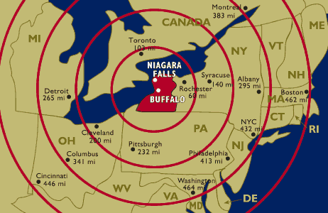 Radius Maps Radius Maps
|
|
Commercial Mapping Sites
- LandVoyage allows for creation of a basic map, or professional quality exhibits, brochures, & general vicinity maps. It will find any land in the USA in under three minutes or search by location, county, zip, section or latitude or longitude. It views satellite, air photo, USGS topos & BLM maps. It can draw a boundary with a mouse or by legal description, measure acres, distances or get latitude longitude coordinates. It enables you to print, download & e-mail low cost maps. For full use of this database there is a $29.00 monthly fee.
- DeLorme. Producer of maps in print and electronic (with GPS-compatibility). Features: TopoUSA maps (CD/DVD editions); Street Atlas USA. Both run on PC and allow for customized maps and measurements that you can develop for yourself.
- Mapquest. Easy-to-read and print maps, directions and destination information to millions of online, voice and wireless users. Easy to take along on the road, MapQuest maps and driving directions can be printed, downloaded to a PDA, emailed or faxed. Useful for travel information, (restaurants, ATM's, entertainment and attractions). Aerial photos show a bird's eye view of surrounding areas.
- Maps.com. Geographix Maps.com claims to be “your one stop shop for maps.” Site attracts over 2,000,000 unique users per month and consistently ranks among the most visited travel websites.
- Omni Resources.
Locate and purchase maps from a major source.
- TopoZone (now part of Trails.com). Interactive topo map of the entire United States. They also are a source for custom digital topographic data sets for Web, GIS, and CAD applications. They have every USGS 1:100,000, 1:63,360, 1:25,000 and 1:24,000 scale topographic map for the entire United States. Place name search to locate areas.
- Trails.com
Contains maps, a trail finder, guidebooks, topo maps for the United States and other countries. Can search by location and activity (hiking, biking skiing…) For full access to information there is a subscription fee of $2.50 per month.
- See also: Where Can I Buy Maps?
|
|
Places for Ideas |
- FlightRadar24. Track aircraft World-wide; with details.
- Vessel Finder. Track vessels in real-time.
- Buzztracker. See the daily news on a map. World map shows news hotspots using density by location/city. Great visualization tool, and you can read the top stories from major news sources world-wide.
- Clickable Maps of Countries
- Butterflies and Moths of North America. An example of maps used for organized sets of data, images, or statistical sets.
- Fall Foliage Map (Boston Globe). Beautiful animated, interactive map showing New England's hotspots for color. The map shows the advance of color changes through the season.
- Globe 4-D. Unique concept products showing maps in the usual 3 dimensions, but also adding the 4th dimension: Time. See the World as it changes through epochs.
- Nuclear Blast Maps of the City of Your Choice. A Google "hack" that allows you to plot the effects of a nuclear blast. choose a city or choose coordinates (-78.79, 43.00000), then size of the weapon. You will see a radius blast zone map, with data on blast ring densities. (From Map Room blog).
- Nuclear Blast Maps of the City of Your Choice [my title]. If you want to know how they calculate the blast effects visit: Nuclear Bomb Effects Computer.
- UIUC Map and Geography Library.
Collection of geographic links from the UIUC Map and Geography Library. Includes: encyclopedias and Almanacs, aerial photographs, gazetteers, maps, Interactive maps, map libraries, map dealers, organizations etc.
For Research and Writing
|
|
Isopleth: a line drawn on a map through all points of equal value of some measurable quantity. In many meteorologic, oceanographic, or geologic studies some physical or chemical property is examined that varies from place to place on a map. Isopleths showing the quantity of the property being studied can be drawn on the map to highlight regional trends of high or low abundance of that property. For example, topographic maps showing contours of equal elevation are probably the most common type of isopleth maps. Relief "highs" (hills) are shown by concentric contour isopleths, and depressions such as volcanic craters are shown by concentric contours with hachures pointing toward the center of the depression.
Isopleths are drawn on weather maps to indicate lines of equal air pressure (isobars) and equal temperature (isotherms). Isobaths are lines connecting points of equal depth in lakes and oceans. Isopach maps show distribution of thickness of a given rock unit. Gravity maps are drawn showing isogals (lines of equal gravitational acceleration). Variations in the strength of the earth's magnetic field are shown by isogams (after gamma, the common unit for measuring magnetic strength).--The Columbia Encyclopedia, Sixth Edition 2006.
|

