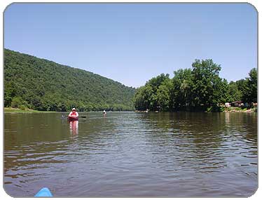
The dramatic hillsides surrounded us down the river
PHOTOS
1
2
3
4
5
6
ROUTE MAP
Click on Map to Enlarge
 |
Description:
I was told by the group I went with that you need a permit to launch your boat (even unmotorized craft) in Pennsylvania waters. There is a cost involved, of course, but I was told it was cheaper than being ticketed by park officials. We passed launch sites on the drive down and saw officials at a few boat launches, so be forewarned!
We had a long drive down to our launch site, and once there, ran another car down to the take-out in Tionesta. The group I went with had kayaks as well as canoes but we took it at a leisurely pace, letting the current of the river carry us most of the way to Tionesta.
Along the way, we were surrounded by the mountains and landscapes of the Allegheny National Forest. The river has a good amount of current, winding through dramatic forest valleys. This would make for an incredible paddle in the Fall. We paddled around numerous islands of varying size throughout our journey, stopping at one for lunch.
We saw many other canoeists and kayakers out on this day, since the weather was especially beautiful. We also caught some canadian geese trying to make their way across, in very shallow water...which forced us to carry our boats through as they were scraping bottom in this section. Usually, I was told, the water level is sufficient to paddle through, but because the summer was so dry that year, many waterways were lower than normal.
All in all, a great day, great company and a very relaxing paddle through some amazing countryside.
Put In: We launched at the foot of the Tidioute bridge (on Rte 62). There was no real parking lot, just the shoulder of a road, next to a nursery. We made sure it was ok with the owners of the business before leaving our cars there for the day. They were very generous in letting us take up their "parking area". We really appreciated it!
Take out:We pulled out our boats just before the town of Tionesta (on Rte 62).
There was a small park there that the group leader knew about. It was just before we approached what looked like small rapids. The take-out was a large beach, covered mostly in small stones. And I'm not sure I would have found it on my own, was glad to have someone with me experienced in this area.
Facilities:
There is a gas station/country store in Tidioute (on Rte 62) where we launched, with bathrooms and supplies.
In Tionesta, there were no facilities where we took out, though the town is just farther down the road.
Distance: 14 miles (this was with current carrying us, which made for about a 6 hour trip)
Portages: None
Loop Trip: No
Camping: Yes
The islands offer good camping in certain sections, but some are privately owned -- the usual rules of respect for private landowners' rights would apply. There are a couple of private campgrounds along the way.
LINKS:
Allegheny River- Good information posted by someone locally
USDA Forest Service - Boating and Canoeing info
Allegheny National Forest Recreation Map - pdf
Tidioute to Tionesta - Driving information
Tionesta Info
|

