Map Reference Update

David J. Bertuca
25 April 2013

Included in this session will be both refresher notes on commonly asked questions, and detailed instruction on several key collections:

Each will demonstrate how to perform these searches, what tools are available, and how you can help patrons find what they want.

Panther Mtn topo
Ampersand topo strip

US Topographic Map Searches

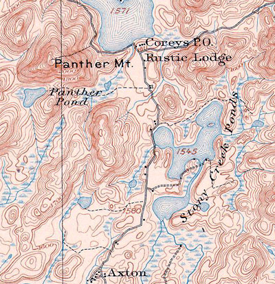
What is a topographic map? This type of map shows "topography" or surface features of the landscape being depicted on the map. Usual features include elevations, contours of elevation, natural and man-made features, etc.

Underwater "topography" is called "bathymetry" and shows terrain on the bottom of water bodies. If the water were drained away, then the map would show "topography." Searching for bathymetric map in BISON is just like searching for topographic maps.

Topographic Maps: How to Use and Read. This page will describe all that you need to know, including symbols, how to find in BISON, examples, where to purchase, and more.

How do you locate topographic maps? This page explains how to locate and use topo map indexes for USGS topographic maps of the United States and dependencies, and how to use BISON to find topo maps worldwide. It also provides links to other topo map resources.

For US topographic maps, the series is divided into two types: current and historic. This is USGS semantics for topos that are pre-1948 and post-1948. The historic topos were drawn at the scale of 1:63,360, while most current maps are 1:24,000-scale. For some states, specific areas were drawn at 1:25,000-scale (1cm = 1km), while Alaska, because of its size, is completed in several main scales. The entire state was not drawn to the same larger-scale as the 48 conterminous states.

The 24,000-scale is 4 times greater in detail than the historic topos. Comparing these to the older maps, four current maps put together show the same area as 1 historic map. This provides more data and resolution than previously available. For the United States, these are generally the largest scale available (exceptions being some major city maps, commercially-, or municipally-produced maps, etc.).

Index MapUSGS Map Indexes are located in the Map Collection on tables near the front of Room 316 Capen. Each state is represented by its own index.

Index sampleThe indexes are maps that have a grid showing the name and location of each map for that state. Simply locate the place that you want to find, then look up the name that is given in the map drawers.

This is all you need to find one-third of the maps in the Collection. Similar map indexes exist for Canadian government-produced topographic maps.

For New York State, a digitized version of the index is on the Map Collection website. You can view this, then select a region to enlarge to find the map titles you need.

Also on the Map Indexes page, are links to other sites that offer electronic map indexes for NYS. Other states are online from USGS and other sources, however, no complete set exists online at this time. Some commercial sites are also providing access to e-versions of the indexes.

To acquire digital topos for other states, Use the Guide: Locating and downloading United States Geological Survey Topographic Maps to help you locate topo maps, in paper and digital formats.

Map indexes for other countries also may be found online to assist in locating maps.

Ampersand topo strip

Searching for NYS Historical Topographic Maps

Historic New York Topographic Maps (pre-1950) may be located at several sites (which also have earlier maps for New England states, among others). The maps were drawn along the same standards as the current topos, which are larger-scale editions using the same base data. They are 4 times smaller in scale than the current 1:24,000-scale topos.

Go to Top of Page

Ampersand topo strip

Digital Sanborn Map searching and use

Sanborn and other fire insurance maps were produced from the second half of the nineteenth century onward and provide a wealth of detail on human structures in America. For historians, planners, anthropologists and archaeologists, genealogists, and for research in almost every field today, these are the most popular cartographic materials available. Their value is beyond almost every other format of this data.

Collections that hold original copies of these types of maps have the ultimate in primary source material; those fortunate enough to be able to refer to the originals are rewarded with a rich, colorful view of specific periods of time and location.

For the rest of us, digitized facsimiles are the next best thing, though they fall short of the originals in their lack of color and aesthetics. But for most research and use, these serve the user very well.

UB has a subscription to New York State digital Sanborn maps. Go to the page that describes Sanborn maps and there are resources and links to other collections of these, as well as instructions on using the digital product. For the present, direct users to this temporary Sanborn Instructions guide that I set up to assist in navigating the database.

Go to Top of Page

Ampersand topo strip

GIS sampleGIS Reference

Geographical Info Systems (GIS) are the most advanced systems for visualizing any data that can be shown spatially. GIS can produce map visualizations that show rerlationships between vital statistics and collected data of any kind, and geographic place, as well as time. Dynamic maps for deep research and for layman's demonstrations can be produced using the same system with user-defined levels of complexity.

GIS is very complex, but it is designed to provide very simple utility for the user. Because of this, GIS will become the most ubiquitous technology of the next decade and beyond.

Finding GIS Data and Systems

For most library research, users will be looking for data and computer files (i.e., "data sets" "shape-files") to load that can be used to build a system on. Here at UB, the first place to start is the GIS section of the Maps & Geography page. Key links on this page include the following:

  • ESRI Virtual Campus Courses. Begin using ArcView and related products. Online tutorials offered along with links to helpful resources.
  • What is GIS? (USGS). Good introduction to GIS, including: data input and how data layers are shown. This is a good page to show someone who wants to understand GIS. Also see: GIS Glossaries for a selection of glossaries/dictionaries of GIS and Cartographic terms. ESRI also has a What is GIS? page.
  • Government Resources (Cartographic). Most government agencies (US, Canada, and other) provide data and GIS-related files to anyone who desires it. Searches of these agencies will uncover a wealth of reliable data.
  • WNY Counties: General Resources. We have built a list for each county in WNY, showing official and other carographic resources and contacts within each county.
  • New York State GIS Clearinghouse. Direct access to data, maps, and GIS materials (some materials require password, Contact David Bertuca (Geosciences Librarian). Includes: 1:24,000 Digital Raster Quadrangles download site, allowing downloads of image files, metadata, and DRQs. Pick from map of the state or from quad index. Has links to 1:250,000 and 1:100,000 scale maps. Also includes:
  • GIS Data Resources is another page with a selected listing of resources available in the Arts & Sciences Libraries and on the Internet.

But I just want to see the GIS for ...

This is also a very hot topic now. People who do not care about how to create a GIS, but want to use the prepared systems for their research or planning. These types of systems may be found online through browser searching and luck. At UB, we have collected some resources for the WNY region and Ontario, as well as for other locations. Start here:

Go to Top of Page

Ampersand topo strip


David J. Bertuca, Map Librarian, Arts & Sciences Libraries

Last Modified: 25 April 2013
URL:
http://www.acsu.buffalo.edu/~dbertuca/maps/map-reference-update.html

Welcome to UB! Click here for Main UB Page