|
|
|
Current Projects
|
| 
|
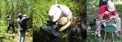 Collaborative
research: Restricted plasticity of canopy stomatal conductance: Conceptual
basis for simplified models of canopy transpiration. National Science
Foundation, Directorate for Geosciences, Hydrological Sciences Division,
April 1, 2004 to April 1, 2007, $388,000 (UB portion is $178,278). Principal
Investigator, with Brent E. Ewers (co-PI, U. Wyoming) and Eric L. Kruger
(co-PI U. Wisconsin). Collaborative
research: Restricted plasticity of canopy stomatal conductance: Conceptual
basis for simplified models of canopy transpiration. National Science
Foundation, Directorate for Geosciences, Hydrological Sciences Division,
April 1, 2004 to April 1, 2007, $388,000 (UB portion is $178,278). Principal
Investigator, with Brent E. Ewers (co-PI, U. Wyoming) and Eric L. Kruger
(co-PI U. Wisconsin).
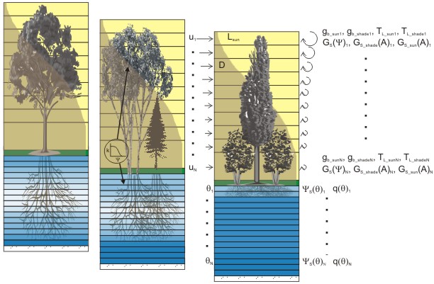
This project seeks
a conceptual model of forest transpiration that embraces the spatial
variability of stomatal control while retaining a tractable measure
of generality that is the hallmark of empirical models of stomatal conductance.
The conceptual model is based on the idea that canopy stomatal conductance
is regulated primarily by water potential when water fluxes are high
and of significant hydrologic import. It is hypothesized here that species
plasticity in canopy stomatal conductance, which determines its spatial
variability and challenge for quantifying, follows a linear relationship
keyed to an easily quantifiable reference conductance. The knowledge
gained from this research has broad implications for land surface modeling
efforts directed at global change effects on water cycling. It will
provide a relatively simple, but transportable and scientifically defensible,
canopy model. Such models are essential foundations for the creation
and implementation of credible policies aimed at mitigating or adjusting
to the consequences of anticipated global change.
|
| |
|
| 
|
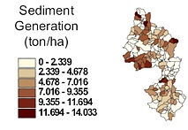
Measuring and modeling
the source, transport and bioavailability of phosphorus in agricultural
watersheds. Environmental Protection Agency (in collaboration with the
United States Department of Agriculture), STAR Grant, Nutrient Science
for Improved Watershed Management Program, $749,307, November 1, 2002
to October 31, 2005. co-PI.
We will measure
and model the sources, transport, and fate of bioavailable phosphorus
(BAP) in the mostly agricultural 604-km2 watershed of Lake Mendota near
Madison, Wisconsin. This well-known eutrophic lake is impacted by phosphorus
(P) loading from agricultural sources, including row crops, dairy operations,
and land applications of manure and commercial fertilizers. The research
will compliment an on-going nonpollution abatement program targeted
at reducing P inputs to the lake through improved management of these
agricultural sources. Our multidisciplinary team provides the expertise
in social science, outreach, environmental modeling, environmental chemistry,
hydrology and sediment transport, environmental engineering, and limnology
– all of which are needed to accomplish our “systems”
goals. Our focus is on the scale-dependent processes that link agricultural
P sources to watershed export of BAP. Our plan involves six major objectives:
1) Quantification of the effects of manure management on runoff BAP;
2) Measurement of the amounts, spatial patterns, and transport of sediment
and BAP in channels and streams acting as routes for transport through
the watershed; 3) Quantification of the in-stream processes governing
the fate and transport of sediment P; 4) Evaluation and improvement
of modeling tools (APEX, SWAT) for assessing P transport over a wide
range of spatial scales; 5) Determination of the relation of BAP losses
to the scale of animal operations; and 6) Integrated outreach with stakeholders,
agency partners and other researchers through farmer-feedback procedures,
agency assessments and model refinement. Knowledge gained will be crucial
for effective state and national TMDL development and implementation.
|
| |
|
|
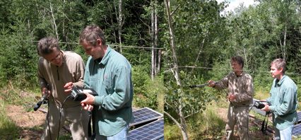
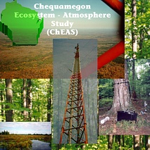
Chequamegon Ecosystem-Atmosphere
Study (ChEAS)
ChEAS is a NSF-funded
interdisciplinary research collaboration network project aimed at understanding
land-atmosphere exchange of cabon, water, and energy at one of the tallest
AmeriFlux towers, located near Park Falls, Wisconsin. The lead institution
for the project is Penn. State University; Dr. Mackay is one of 6 members
of the ChEAS steering committee.
|
| |
|
|
Terrestrial Regional
Ecosystem Exchange Simulator (TREES)
We are developing
this object-oriented land surface process model, which provides the
flexibility to examine model complexity requirements, for application
to flux towers, watersheds, and remote sensing regional scale projects.
Data handling is through a data dictionary, which supports rapid definition
of frames for the input of data, maintenance of state and flux variables,
and output of model results. The flexibility afforded by objects is
exploited for rapidly developing simulation models that are tailored
to specific analytical requirements. Early TREES development began with
a version of RHESSys developed as part of Mackay's PhD dissertation.
Subsequently, TREES has departed from the RHESSys approach in that it
relies on a pure object-oriented approach.
|
| |
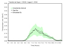 |
Adaptive Parameter
Restriction and Selection (APReS)
We are developing
a general framework for the analysis of uncertainty in simulation models.
Our approach is motivated by methods such as GLUE and Parato Optimality.
The premise of APReS is that parameter uncertainty and even model structure
uncertainty are interpretable in terms of fuzzy sets. A nonmonotonic
reasoning approach is supported to allow for the evaluation of simulations
based on multiple criteria in different combinations and priorities.
APReS has been applied to simulation of streamflow in forested watersheds,
transpiration at hillslope to watershed scales, and to transpiration
at individual tree and whole-stand scales. It is currently being used
as one of numerous analytical tools for projects funded by NSF and EPA.
|
|
Past Projects
|
| |
Long-term
water flux changes from converting old-growth pine forests to hardwood
forests in northern Wisconsin. NASA, Land Surface Hydrology Program,
NAG5-8554, $359K (1999-2002), Mackay (PI).
Highlights and milestones
of the Land Surface Hydrology Project were:
1. A comprehensive
database of vegetation, water fluxes, micrometeorology, remote sensing,
soil moisture, tower flux, and process-based models were used in the
first successful scaling-up exercise at the WLEF tower (Mackay et al.,
2002; Ahl et al., 2004b).
2. An essential bridge was developed between leaf and tower flux measurements
with measurements of leaf water potential and transpiration among seven
key species in the WLEF tower footprint (Ewers et al., 2002; Ewers et
al., 2004).
3. Accurate simulations of transpiration models and parameterization
for the heterogeneous forests around WLEF (Mackay et al., 2003a,b; Samanta
and Mackay, 2003).
4. We developed a parameterization scheme to use MODIS land surface
temperature to estimates canopy stomatal conductance for simulation
transpiration and photosynthesis (Mackay et al., 2003c; Mackay et al.,
2004).
|
-
Distributed
parameter non-point source pollution modeling in nested watersheds:
Guide to implementing legislated surface water quality restrictions
in Wisconsin. Hatch/McIntire-Stennis, $90K, October 2000 to September
2004, Mackay (PI).
-
Context
elicitation to support the semantic integration of environmental
models. University of Wisconsin Graduate School Fall Competition,
$15K, July 2000-June 2001, Mackay (PI).
-
Long-term
water flux changes from converting old-growth pine forests to hardwood
forests in northern Wisconsin. University of Wisconsin Graduate
School Fall Competition. Awarded $20K for 1999-2000, but not used.
-
Effects
of parameter spatial aggregation on agricultural non-point source
pollutions models. US EPA (Pass-through from Wisconsin Department
of Natural Resources), $15K (1999-2000), Mackay (PI).
-
Remote
sensing teaching and research in support of creating a vision for
the environment as a whole. NASA, Centers of Excellence in Remote
Sensing, NAG5-6535, $424K (1997-1999), Mackay (PI). (Equipment Grant).
-
Coupling
forest ecosystem process-based models to groundwater models: tools
to guide natural resource management in northern Wisconsin. Funded
by McIntire-Stennis. $200K (1997-2001), Mackay (co-PI) with Gower
(PI).
-
Affiliated
Research Center (ARC). NASA., Mackay (one of several co-investigators)
with Lillesand (PI), 1996-2001.
-
ARCII.
NASA, Mackay (one of several co-investigators) with Lillesand (PI),
2001-2006.
-
Scaling
spatial simulation of forest disturbance on watershed processes,
University of Wisconsin Graduate School Fall Competition. $21K (1997-1998),
Mackay (PI).
-
Characterization
of evapotranspiration and forest water relations in northern Wisconsin.
University of Wisconsin Graduate School Fall Competition. Awarded
$15,792, July 2001-June 2002.
-
Chequamegon
Ecosystem-Atmosphere Study. National Science Foundation, Division
of Biological Sciences, Research Collaboration Network Program.
Mackay one of several co-investigators with Ken Davis, Penn. State
(PI), January 1, 2002 to December 31, 2006.
-
Development
and Evaluation of TMDL Planning and Assessment Tools and Processes.
USDA CSREES Regional Project DC 00-02, Theo Dillaha, U. Virginia
(PI). Mackay, one of two UW-Madison representative, October 1, 2001
to September 30, 2006.
-
Quantifying
non-point source phosphorus losses from field to watershed scales.
University of Wisconsin Graduate School Fall Competition, $23,353,
Interdisciplinary, July 2002-June 2003; co-investigator with K.G.
Karthikeyan as PI.
-
WebGrant
Award. University of Wisconsin Division of Technology instruction
web page improvement award, $750; Web page development for Regional
Hydrology.
|
|
© 2005 D.S. Mackay Department
of Geography, 105 Wilkeson Quadrangle, Buffalo, NY 14261 |