Research Interests
My research program examines various aspects of erosion and sedimentation primarily in fluvial systems through the use of experimentation, theory, field studies, and numerical modeling. The overall goals of the research are to quantify flow and sediment transport processes using an interdisciplinary approach and to determine the impact of these processes on river form and function, water quality and ecology, landscape evolution, and watershed infrastructure and integrity. This work is fundamentally important because sediment is one of the leading causes of water quality impairment nationwide, and soil erosion is the leading cause of soil degradation worldwide. Excessive sedimentation also reduces the performance of flood-control reservoirs and increases risks to flooding within river corridors. Below is a brief description of these activities, divided into four categories.
Flow and Sediment Transport Processes
in Streams and Rivers
For uniform and steady flows in rivers, the entrainment and transport of sediment
of various sizes, shapes, and densities depend on the gravitational and frictional
forces keeping the grains in place, the time- and space-varying fluid forces
acting to move and suspend the particles, and the development of bedforms that
further modulate boundary layer characteristics. Work to date, utilizing state-of-the-art
instrumentation, has focused on the following topics.
|
|
|
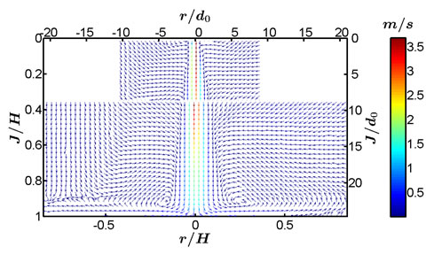
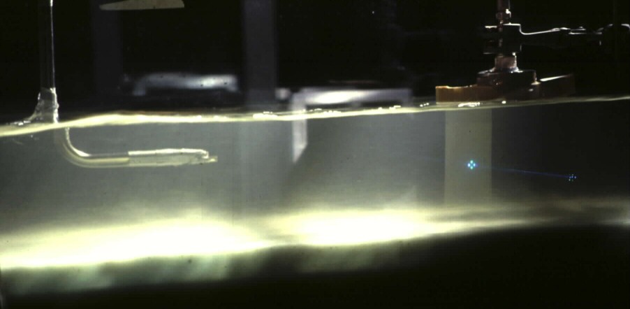
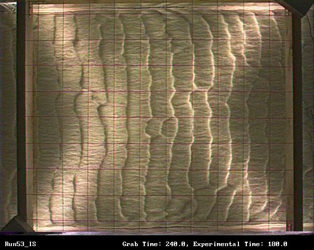
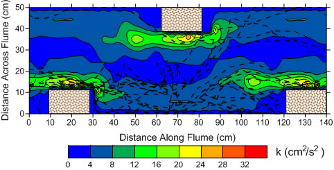
| Turbulent flow field of an impinging jet described in Ghaneeizad et al. (2015) | Phase Doppler anemometer described in Bennett et al. (1998; flow is right to left) | RIpple bedforms described in Venditti et al. (2005; flow is left to right) |
|
|
|
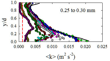
| Turbulence modulation within a mixing due to the presence of suspended sediment (see Bennett et al., 2015) | Low-relief bedwave (bedload sheet) described in Kuhnle et al. (2006; flow is left to right) | PIV laser being used to illuminate fluorescent tracer particles in a mixing box (Bennett et al., 2014) |
Some representative papers recently published include:
Erosion Processes on
Hillslopes and Upland Areas
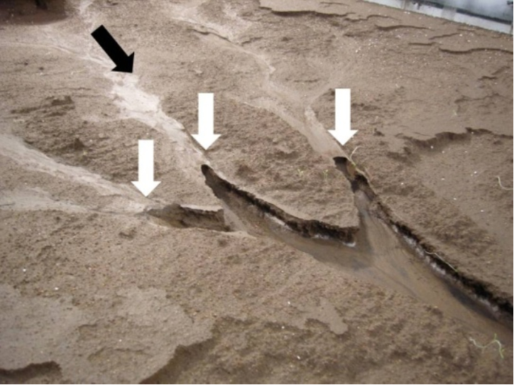
Rill and gully development in upland concentrated flows occur as a discrete
soil erosion process intimately related to the occurrence and upstream migration
of headcuts. These areas of intense, localized erosion often are the primary
cause of soil loss and the dominant source of sediment yield from agricultural
landscapes. The formation, growth, and migration of headcuts has been linked
to the concentration of overland flow, rill and gully erosion and development,
erosion of bedrock channels, the initiation of drainage systems and landscape
evolution, and the response of landscapes to land use change and extreme hydrologic
events. Work to date, utilizing specially-designed experimental facilities and
state-of-the-art instrumentation, has focused on the following topics.
 |
 |
 |
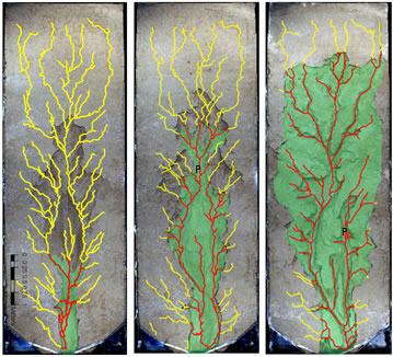
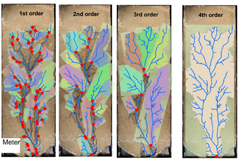
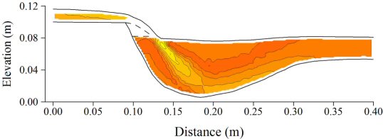
| Orthophotographs of the time-variation in rill development showing the surface drainage network (in yellow) and the incised rill network (in red, with green drainage areas; see Bennett et al., 2015) | Images of the soil-mantled experimental landscape showing the boxes used to define the basin length scales for the 1060 min bed surface for four rill orders, where the red circles define the mouth of each sub-basin (see Bennett and Liu, in press) | Photographs of Type A headcut bifurcating along lines of concentrated flow (see Gordon et al., 2012) |
 |
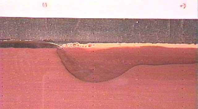 |
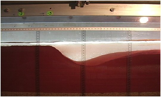 |
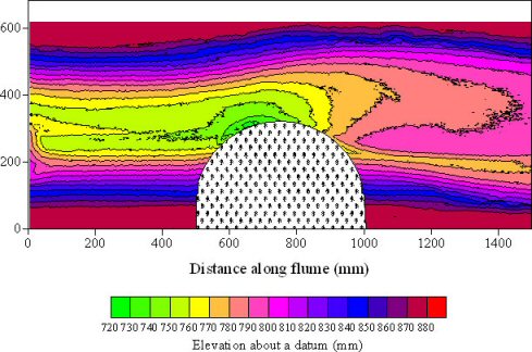
| Velocity magnitude within a headcut plunge pool described in Bennett and Alonso (2006; flow is from left to right) | )Actively migrating headcut described in Bennett et al. (2000; flow is from left to right) | A migrating heacut arrested in place by raising the tailwater control described in Wells et al. (2009b; flow is from left to right) |
Some representative papers recently published include:
Riparian Vegetation and
Fluvial Geomorphology
Because of increased popularity of vegetation in stream restoration and streambank
stabilization programs, there is renewed interest in examining the interactions
between river flow, riparian vegetation, and large woody debris or engineered log jams. There are instances,
however, when bank instability causes excessive recruitment of large woody debris,
which can effectively choke downstream river corridors as witnessed along the
Yalobusha River, MS. The overall goals of the current research program are to
assess the interactions between open channel flow and rigid vegetation and to
determine how river flow processes and forms are modulated such vegetation.
Work to date, utilizing various techniques and facilities, has focused on the
following topics.
 |
 |
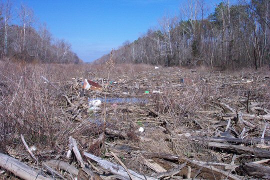 |
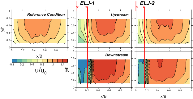
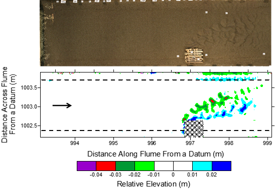
| Hydraulic adjustment to engineered log jams (ELJ-1 and ELJ-2) within a fixed-bed open channel flow described in Bennett et al. (2015) | Channel adjustment to an engineered log jam (ELJ-1) in a movable-bed open channel flow (Gallisdorfer et al., 2014) | Large woody debris accumulation along the Yalobusha River, MS described in Bennett and Rhoton (2009; looking upstream) |
 |
 |
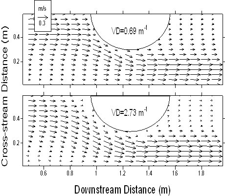 |
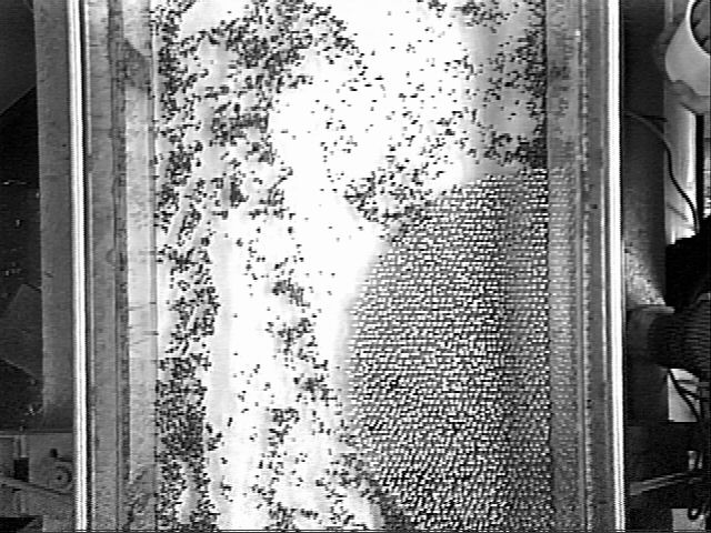
| Turbulent flow around emergent, rigid vegetation using particle image velocimetry described in Bennett (2004; flow is from bottom to top) | Alluvial response to managed plantings of rigid, emergent vegetation (staggered pattern placed in a semi-circular arrangment) within an experimental channel as desribed by Bennett et al. (2008; flow is from left to right) | Spatially-averaged surface flow vectors for a fixed-bed experimental channel with alternate zones of emergent, rigid vegetation (staggered pattern placed in a semicircular arrangment (only a portion of the flow field is shown; Bennett et al., 2002) |
Some representative papers recently published include:
Assessment of Stream and Landscape Degradation and Restoration
Environmental scientists now can play a critical role in the assessment and management of degraded landscapes and become actively engaged in policy. This could include assessing impaired stream corridors, examining fish passage requirements, evaluating regions designated for environmental justice, and considering the economic opportunities of landscapes in transition. My colleagues have initiated several research projects focusing on the following topics.
 |
 |
 |
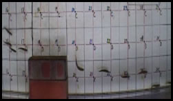
| Photograph of an emerald shiner (on left) within a pipe used to assess swimming capability | Photograph of blacknose dace swimmming usptream through a turbulent flow field as described by Goettel et al. (2015) | Pathlines of individual blacknose dace as they moved upstream (left to right) through the flow field of turbulent kinetic energy as described by Goettel et al. (2015) |
Some representative papers recently published include:
Sedimentation Issues
in Flood-control Reservoirs
There are more than 75,000 dams in the continental U.S., and these structures
provide opportunities for navigation, hydroelectric power, irrigation, flood
reduction, and hazard protection. Yet these dams divide or segment watersheds
with respect to water, sediment, nutrient transfer, and ecosystem dynamics.
Because reservoirs effectively trap sediment, these impoundments have proven
to be important environmental “archives” of changes in water quality
parameters, land use, and sediment yield. The overall goals of the current research
program are to assess the sediment impounded by these dams in terms of the structure’s
ability to regulate floodwaters and the potential hazard these sediments may
pose to the environment. Work to date, utilizing various techniques, has focused
on the following topics.
 |
 |
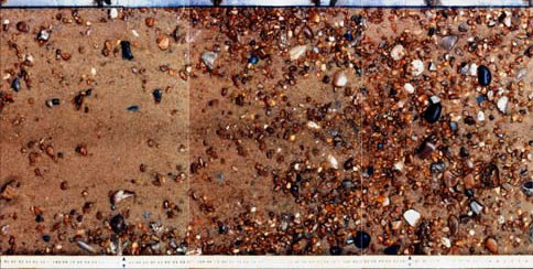
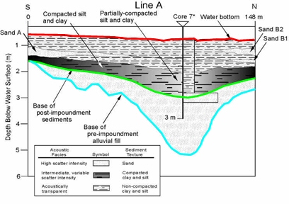
Stratigraphic
intrepretation of impounded sediment described in Bennett and Dunbar (2003) |
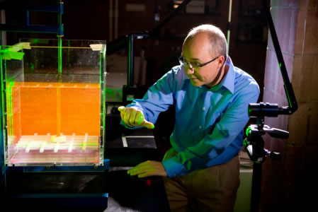
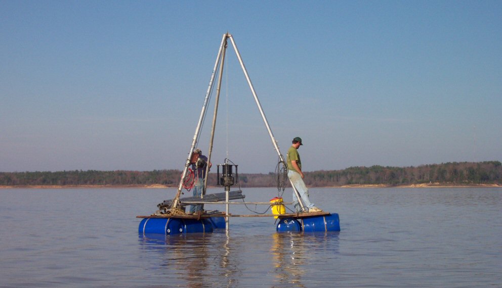
Vibracore
system on Grenada Lake, MS described in Bennett et al. (2005) |
 |
 |
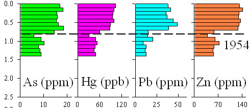
Variations in arsenic, mercury, lead, and zinc concentrations within the sediment below the bottom of Grenada Lake, MS, showing the time of reservoir construction (1954) as described in Bennett and Rhoton (2007) |
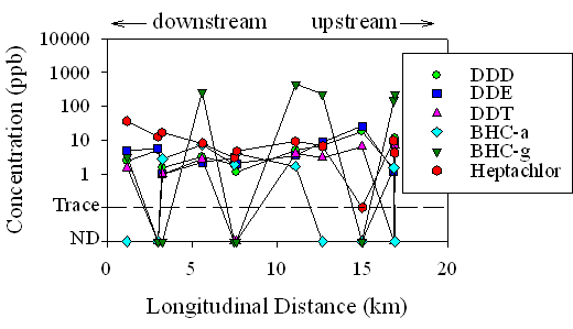
Spatial variation in depth-averaged agrichemical concentrations within the impounded sediment of Grenada Lake, MS along the Yalobusha RIver arm as described in Bennett and Rhoton (2009) |
Some representative papers recently published include: