
Collaborative LTREB: Experimental and observational studies of mangrove forest structure and gap dynamicsNational Science
Foundation Award # 0810933 #0614040 Oct.
1, 2006 – Sept. 30, 2011 |
|
|
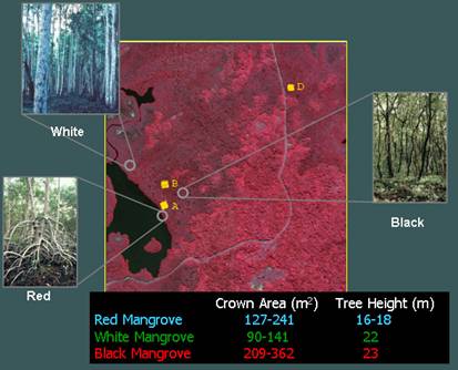
2000 IKONOS Imagery illustrating three different
mangrove species in our study site at |
Principal Investigator:Le Wang Department of Geography Collaborative Investigator:Department of Integrative Biology |
Summary
Mangroves, once occupied 75% of the world’s tropical and
subtropical coastlines, are a unique forest type that provide critical
“ecosystem services”, one of which was recently evidenced in the 2004 Indian
Ocean Tsunami, i.e. areas with intact seaward mangrove forests suffered much less
human death and property destruction than otherwise. Unfortunately, the
persistence of these important and distinctive coastal ecosystems is gravely
threatened by a plethora of human-caused environmental perturbations. Previous research estimated that as much as
a third of the world’s mangrove forest have been lost in the past 50
years. In the |
|
Publications
- Wang, L., and W. Sousa. Distinguishing mangrove
species with laboratory measurements of hyperspectral
leaf reflectance, International Journal of Remote Sensing, in press.
- Wang, L., J. Silvan, and
W. Sousa. 2008. Neural network classification of mangrove species from multiseasonal IKONOS imagery, Photogrammetric
Engineering and Remote Sensing, 74(7): 921-927.
- Wang, L., W. Sousa, and P. Gong. 2004. Integration
of object-based and pixel-based classification for mangrove mapping with
IKONOS imagery, International Journal of Remote Sensing 25(24):
5655-5668.(the #1 mostly downloaded paper in 2005 with IJRS)
- Wang, L., W. Sousa, P. Gong, G.S. Biging. 2004. Comparison of IKONOS and QuickBird images for mapping mangrove species on the
Caribbean coast of