Niagara Gorge
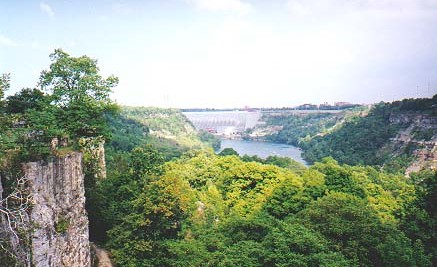
The Niagara Gorge is a seven-mile long gorge that contains a fascinating
mixture of forest types and serves as an important part of the tourist
experience of many millions of people each year. Although much is known
about the Niagara Falls at the head of the gorge, and although there
have been numerous botanical surveys of the gorge forests, very little
is known about the geography or history of the plant communities of the
gorge. Two studies I am planning are as follows.
Ecosystem dynamics and ecological restoration
What forest types are present in the Niagara Gorge, and how have they
changed over time? To answer this, the present forest types will be
surveyed, sampled and mapped using GIS and Remote Sensing.
The development of the present-day forests will be reconstructed using
aerial photographs that date back to the 1920s, tourist photographs that
date back to the 1880s, botanical records that date back to the 1850s,
and tree-ring records that date back to the 1500s.
A restoration plan for the forests of the Niagara Gorge will be
developed by creating a GIS model using the map of current forest types
and the historical reconstruction of the forest composition.
Mapping of landscape aesthetic
The Niagara Gorge contains a diversity of landscape types that offer
unique aesthetic experiences. The experience of most people is limited
because of accessibility, and because they don't know what is available
in the Gorge.
Landscape aesthetics of the Niagara Gorge will be recorded while
surveying the forest as part of the "Ecosystem dynamics" project. Sites
will be categorized using a combination of Appleton's "prospect-refuge" theory, the Kaplans' preference framework, and Berlyne's
sensory arousal.
Types of aesthetic experience will be modeled using GIS and mapped in a
form that allows recreationists to explore the Gorge to find experiences
that match their desires.