| Name | Last modified | Size | Description | |
|---|---|---|---|---|
| Parent Directory | - | |||
| catmapline-r.jpg | 2008-10-28 10:08 | 14K | ||
| spingold.gif | 2008-10-28 10:15 | 5.2K | ||
| map-cat-sitemap.jpg | 2008-10-29 10:40 | 205K | ||
| dbmail.gif | 2008-10-29 10:40 | 400 | ||
| blueline.jpg | 2008-10-29 10:40 | 9.9K | ||
| dagger.gif | 2008-10-29 10:41 | 299 | ||
| catmapline.jpg | 2008-10-29 10:41 | 13K | ||
| cutter.html | 2008-10-29 11:00 | 3.4K | ||
| map-cataloging-outli..> | 2008-10-29 16:05 | 9.4K | ||
| map_examples.html | 2008-10-29 16:05 | 15K | ||
| oclc_records_example..> | 2008-10-29 16:28 | 55K | ||
| alaska.html | 2008-10-29 16:28 | 43K | ||
| Class.html | 2008-10-29 16:28 | 33K | ||
| map-cat-sitemap.html | 2008-10-29 16:28 | 3.6K | ||
| geo_references_links..> | 2008-10-29 16:30 | 107K | ||
| MapCatCourse.html | 2008-10-29 16:32 | 1.8K | ||
| mapcats.jpg | 2008-10-29 16:36 | 46K | ||
| rivers_china_india_l..> | 2008-12-10 16:13 | 13K | ||
| map_cat_cover.html | 2008-12-10 16:20 | 2.7K | ||
| map_cat_course.html | 2008-12-10 16:20 | 21K | ||
| ontario-prov-parks-l..> | 2008-12-10 16:20 | 34K | ||
| names-common.html | 2008-12-10 16:21 | 12K | ||
| map_cataloging_works..> | 2008-12-10 16:21 | 8.1K | ||
| map_cataloging_works..> | 2008-12-10 16:21 | 7.9K | ||
| map_cat_index.html | 2008-12-10 16:21 | 5.2K | ||
| imagesNEXT.html | 2008-12-10 16:21 | 11K | ||
| images.html | 2008-12-10 16:21 | 9.4K | ||
| 2734.html | 2008-12-10 16:21 | 5.2K | ||
| geo_name_xref_list3...> | 2008-12-10 16:21 | 227K | ||
| geo_name_xref_list2...> | 2008-12-10 16:21 | 145K | ||
| 7-5-minute-samp.jpg | 2009-06-08 16:03 | 66K | ||
| contours-spot.jpg | 2009-06-08 16:03 | 147K | ||
| crater-lake-bathy2.jpg | 2009-06-08 16:03 | 170K | ||
| crater-lake-bathy.jpg | 2009-06-08 16:03 | 147K | ||
| paris-birdseye.jpg | 2009-06-08 16:03 | 291K | ||
| projected-map-image.gif | 2009-09-08 10:45 | 6.5K | ||
| us-threeprojections.gif | 2009-09-08 10:45 | 9.3K | ||
| cylindrical_final.gif | 2009-09-08 10:46 | 14K | ||
| conic8_ed.gif | 2009-09-08 10:46 | 10K | ||
| azimuth-equid.gif | 2009-09-08 10:46 | 8.5K | ||
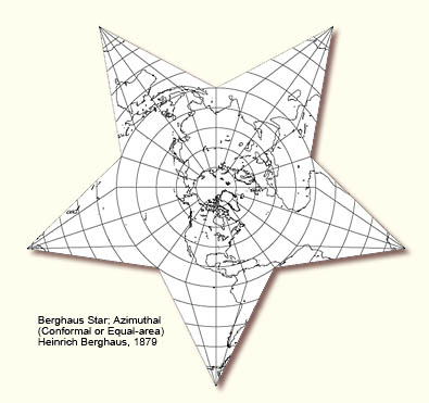
| Berghaus_Star.jpg | 2009-09-08 10:47 | 53K | ||
| heart-werner2.jpg | 2009-09-08 10:47 | 83K | ||
| Land_Sea_Hemispheres..> | 2009-09-08 10:48 | 65K | ||
| schedule_g.html | 2009-09-08 12:59 | 23K | ||
| map_cat_cover.jpg | 2009-09-08 14:21 | 61K | ||
| naut-chart.jpg | 2009-09-08 14:49 | 166K | ||
| hist-topo-drawer.jpg | 2009-09-08 15:01 | 100K | ||
| map-title.jpg | 2009-09-08 15:03 | 71K | ||
| map-corner1.jpg | 2009-09-08 15:03 | 72K | ||
| map-corner2.jpg | 2009-09-08 15:03 | 56K | ||
| map-scale.jpg | 2009-09-08 15:04 | 45K | ||
| top.jpg | 2009-11-12 09:35 | 34K | ||
| map_cat_tools.html | 2009-11-12 10:04 | 1.2K | ||
| loc-logo.jpg | 2010-04-27 15:54 | 23K | ||
| oclc-logo.gif | 2010-04-27 15:55 | 2.2K | ||
| connexion.jpg | 2010-04-27 15:55 | 25K | ||
| relief-hypso-shading..> | 2010-05-17 14:00 | 135K | ||
| contours-created.jpg | 2010-05-17 14:00 | 77K | ||
| scale-not-given.jpg | 2010-05-17 14:00 | 165K | ||
| hypsometric.jpg | 2010-05-17 14:00 | 49K | ||
| hypsometric-tints-ma..> | 2010-05-17 14:00 | 100K | ||
| relief-samples2.jpg | 2010-05-17 14:00 | 250K | ||
| shading.jpg | 2010-05-17 14:00 | 87K | ||
| plat-map.jpg | 2010-05-17 14:00 | 107K | ||
| hachures2.gif | 2010-05-17 14:08 | 35K | ||
| hachures-types.jpg | 2010-05-17 14:09 | 111K | ||
| relief-samples.jpg | 2010-05-17 14:28 | 121K | ||
| landforms2.jpg | 2010-05-17 15:00 | 92K | ||
| campchase.jpg | 2010-05-17 15:00 | 70K | ||
| scale-bar-usgs.jpg | 2010-05-17 16:47 | 46K | ||
| 255-034.pdf | 2010-05-17 17:13 | 67K | ||
| math-data.pdf | 2010-05-17 17:14 | 19K | ||
| coordinates.pdf | 2010-05-17 17:16 | 14K | ||
| dover-bot-c.jpg | 2010-05-18 12:28 | 73K | ||
| dover-bot-l.jpg | 2010-05-18 12:28 | 79K | ||
| dover-bot-print.jpg | 2010-05-18 12:28 | 59K | ||
| dover-bot-r.jpg | 2010-05-18 12:28 | 124K | ||
| dover-up.jpg | 2010-05-18 12:29 | 62K | ||
| dover-up-l.jpg | 2010-05-18 12:29 | 68K | ||
| dover-up-r.jpg | 2010-05-18 12:29 | 38K | ||
| dover-w-nh-93guide.jpg | 2010-05-18 12:29 | 124K | ||
| map-terms.jpg | 2010-05-18 12:36 | 110K | ||
| scale-not-given2.jpg | 2010-05-18 16:19 | 76K | ||
| scale-note.jpg | 2010-05-18 16:19 | 30K | ||
| map_cat_coverNEW.jpg | 2010-05-19 17:34 | 60K | ||
| map-cataloging-works..> | 2010-05-19 22:34 | 34K | ||
| map-cataloging-outli..> | 2010-05-19 22:37 | 14K | ||
| map-cataloging-works..> | 2010-05-19 22:47 | 16K | ||
| Thumbs.db | 2011-04-07 13:37 | 30K | ||
| cataloging.html | 2013-04-29 14:42 | 34K | ||
| name-fields.html | 2013-04-29 14:43 | 5.3K | ||
| scale-measuring.html | 2013-04-29 14:43 | 7.5K | ||
| map-portion-images.html | 2013-04-29 14:43 | 11K | ||
| title-fields.html | 2013-04-29 14:44 | 32K | ||
| example-portion-dove..> | 2013-04-29 14:44 | 4.2K | ||
| dover-west-quad.html | 2013-04-29 14:44 | 3.1K | ||
| geo_name_xref_list.html | 2013-04-29 14:49 | 223K | ||
| map-projections.html | 2013-04-29 14:49 | 7.9K | ||
| sample-mars-record.html | 2013-04-29 14:56 | 8.1K | ||
| note_fields.html | 2013-04-29 14:56 | 28K | ||
| RDA/ | 2013-04-29 14:57 | - | ||
| lc_map_subdiv.html | 2013-04-29 14:57 | 4.8K | ||
| sample_record.html | 2013-04-29 14:57 | 7.9K | ||
| sample_record2.html | 2013-04-29 14:58 | 8.7K | ||
| canada-islands.html | 2015-03-31 12:17 | 62K | ||
| geo_maps.html | 2017-10-19 15:27 | 38K | ||
| fields.html | 2018-01-24 14:15 | 71K | ||
| map-cat-toolbox.html | 2019-06-26 13:39 | 46K | ||