Events & History
Best General
Resources & Latest Reports
- National
Hurricane Center / Tropical Prediction Center (National
Weather Service). Start here. Current and historic data,
satellite weather images, photos, plotting charts, and many other
resources. If you live in an area that is prone to hurricanes
and tropical storms, this is the place to find current data and
predictions.
Also has the official list of Worldwide
Tropical Cyclone Names.
- Climate
of 2005: Hurricane Katrina Summary (NCDC).
Excellent site. Provides climate/weather history of the hurricane,
compares Katrina to past megastorms, and has a great deal of data,
maps, and description of the "tropical storm cycle."
- Federal Emergency
Management Agency (FEMA).
 Latest info on relief efforts,
status of disaster areas, how to help, how to prepare, and more. Latest info on relief efforts,
status of disaster areas, how to help, how to prepare, and more.
- Hurricane Katrina Flood Recovery Maps. View and download maps, GIS data on current relief and recovery efforts.
- Hurricane
Research Division Links (NOAA/AOML).
Essential links for everything on hurricanes.
Local News
For current stories, not Katrina-related
Special Pages by News
Services (with links to good resources)
- Hurricane
Katrina Special Report (CNN). News
and events about and following the disaster (Includes related information for a year after). Includes a comprehensive
listing of resources, images, data, and links to additional sites,
not only for New Orleans, but for all Southern states affected
by the hurricane. Includes: People, Locations, Health, and Economics,
plus video, audio, and documentary articles by survivors.
- Hurricane
Katrina in Depth (BBC). News and
events, plus other information, similar to the CNN site. Includes
coverage of all
states. View a map
of what states have taken in refugees.
- Hurricane Katrina (Katrina.com).
Site by a Web designer, named Katrina, who has voluntarily worked
to provide excellent links to resources and emergency phone
numbers, etc.
- Hurricane
Special (New York Times). News, stories,
images, videos, links to all materials.
- Hurricane Katrina Information Guide (Middletown
Thrall Library). Great list of links to news, information,
images, relief efforts, and various commentary pages.
- Katrina
Special Coverage (National
Geographic News).
- Hurricane
Katrina (GlobalSecurity.org). Includes information on relief
efforts.
- See also: Ten Years Later; One Year Later.
News Services (for Updates)
Images, Maps, GIS (Check all sites for images and maps)
Images
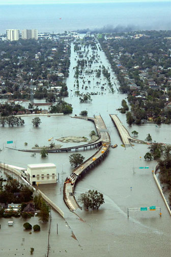
- Hurricane
Katrina Images (NOAA). Coverage of Louisiana, Mississippi,
and Alabama. Has an index map for ease of use in locating areas. If you are searching for specific neighborhoods and houses,
this one will help.
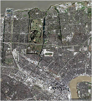
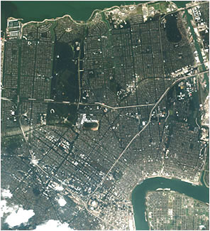
- Before
and After Images of various sites around New Orleans. Also
has annotated images of the flooding, and other aspects. (GlobalSecurity.org).
- Damage Assessment Maps (FEMA):
Maps
- Hurricane
Katrina Mapping Response (LSU World Health Organization
Collaborating Center for Remote Sensing and GIS for Public Health).
Louisiana State University is close to the situation and has
been compiling images, GIS, and links to maps and imagery of
all types.
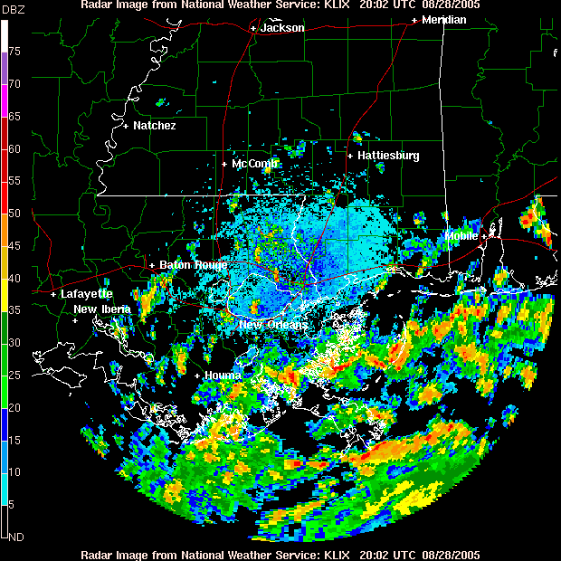
- Radar
Loop of the hurricane as it hits Louisiana (Slidell, LA
radar station).
- Katrina
Satellite and Radar photos (Goddard Space Flight Center).
Shows before and after comparison images, radar and map images
of the storm, and an animation showing the levels of the water
in New Orleans during the storm surge.
Other News & Photo Sources
Relief Efforts and
Contacts
This section no longer pertains directly to Katrina relief, however it may be useful in a future disaster and is left as a model for planners.
See also: Special Ways to Help 
- American
Red Cross. Ways to assist, including giving
blood, donating
money, and supplies, as well as how to prepare for emergencies.
- Federal Emergency
Management Agency (FEMA). Latest info on relief efforts,
status of disaster areas, how to help, how to prepare, and more.
- Salvation Army
National Headquarters Storm Refugee Service. Ten years later, still looking for donations of
clothing, goods, and money to assist recovery.
- White
House Katrina Relief page. Government agencies and private
groups' efforts, along with other relief news.
How to Contact States for Help, Information,
Assistance Finding Relations
This section no longer pertains to Katrina, however it will be useful should another hurricane disaster hit the region.
Official State Contacts
Ten Years Later
One Year Later
Though most of the sites on this page include current relief efforts and restoration data, here aresamples of some of the damaged cities and towns and how they are coping a year after the storms.
- Katrina: One Year On (BBC). News coverage of recovery and the issues affecting recovery.
- Hurricane Katrina (Katrina.com).
Site by a Web designer, named Katrina, who has voluntarily worked
to provide excellent links to resources and emergency phone
numbers, etc.
- Waveland,
Mississippi (considered "ground zero" for Katrina)
Hurricane Science
 Damage Reports and Data Damage Reports and Data
Hurricane
Awareness & Preparedness
Severe Weather Warning Centers
Disaster Preparation
For Kids
Additional Sources for References
- U.S.
Serial Set Digital Collection. This has many documents pertaining
to previous New Orleans hurricane disasters, some of which include
maps. Available online to
some institutions, but also the print editions can be located in
most U.S. Government Depository libraries. A sample of some relevant
map titles include:
- Improvement of Mississippi River
levee in front of New Orleans (1882).
- Atchafalaya, Lafourche & Pontchartrain
Levee Districts (1895).
- Sketch map of New Orleans Land
Company tract, New Orleans, La.,
showing arrangement of ditches and levees (1910).
- Report on interim hurricane survey
of Mississippi River Delta at and below New Orleans,
La. (1962).
- Report on interim hurricane survey
of Lake Pontchartrain and
vicinity, La. (1965).
 Causes and Perceptions
of Katrina, Rita Causes and Perceptions
of Katrina, Rita
Natural or man-made disasters create
a variety of responses from people as to "why did this happen?"
Below are a few sample articles (ranging from scholarly to spiritually)
on the wide range of "reasons" for the hurricanes. These
are provided simply for discussion and do not reflect
views of the page author.
- God,
Cosmos, Katrina and Rita. An article on what people believe
causes great disasters. " The desire to assign cosmic significance
to the arrival of hurricanes Katrina and Rita is an example of
humankind's ages-old need to find reason within chaos, according
to University at Buffalo anthropologist Phillips Stevens Jr., Ph.D.,
a renowned expert on the origins, nature and meaning of cults, superstitions
and cultural identities."
- Is
Global Warming Fueling Katrina? (Time article).
- Perceptions, rumors, and other "beliefs" fuel
the debate. These below are just a few examples.
Special Ways to Help |
