 History & Events History & Events
Latest Reports
Current
Status Reports (ReliefWeb). Updates
on progress, status of loans and other activities as the region recovers.
Of special interest is:
South/Southeast
Asia and East Africa: Earthquake and Tsunamis: Fact Sheet no. 14 (ReliefWeb
Aug. 9, 2005) Status Reports for Countries prepared by the
International Federation of Red Cross And Red Crescent Societies (IFRC). News Special Pages
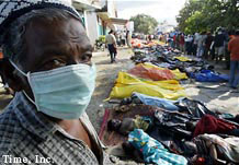
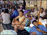
- After
the Tsunami (CNN). News and events about and following the
disaster. Includes resources, images, data, and links
to additional sites. Several topics included are:
- Asian
Quake Disaster In Depth (BBC) News and events, plus other
information, similar to the CNN site.
- Asia's
Deadly Waves (New York Times). News, stories, images, videos,
links to all materials.
- Asia
Earthquake and Tsunami (FirstGov). From official phone contacts
to history and data, this is a good starting point.
- EQ Net Tsunami Disaster page. From general coverage
to specific technical data on
 the events. the events.
- Dec
26, 2004 Magnitude 9.0 Earthquake & Tsunami in the Indian
Ocean (National Geophysical Data Center (NGDC) at NOAA). Event
history, maps, animations, and data.
- National
Geographic News full coverage page. On the tsunami, including
news, photographs, maps, related topics, and many articles. Includes
historical articles as well, such as:
The
Deadliest Tsunami in History?
and
Tsunamis:
Facts About Killer Waves.
- Tsunami Event
26 December, 2004 (NOAA). Good data and information, plus updated
links.
- Indian
Ocean Casualties Map (Washington Post).
News Services (for Updates)
 Southeastern Asian News Services (by country) Southeastern Asian News Services (by country)
Images, Maps, GIS, and Video
- News & Amateur Photos (and some
videos)
- BBC (see
links in right column)
- CBC (satellite
photos, other)
- CNN (photos,
maps, graphics, satellite, personal photos)
- CTV.
Special showing photos taken by a pilot over the Maldives during
the
 tsunami from the air, then on the ground. tsunami from the air, then on the ground.
- NBC.
Images and videos.
- New
York Times (many clean-up/aftermath photos)
- NPR. Map of the region.
- Der
Spiegel. Maps and images.
- USA
Today. Animated maps show the tsunami and damage/death
statistics.
- Base
mapping over SE Asia tsunami. Maps from GIS of countries.
- Tsunami
gallery (DigitalGlobe). The producer of many of the satellite
views.
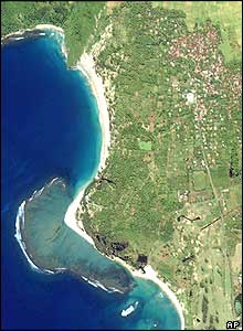
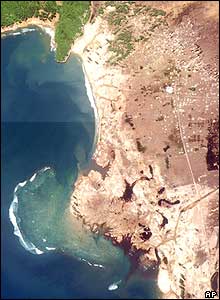
- Before/After
Satellite Images (NASA/JPL). Toggle between images showing
various points in the disaster.
- Before/After
Satellite Images (Washington
Post). Images of Banda Aceh, Indonesia. Click between before
and after images that are super-imposed for graphic view of destruction.
(May require email registration to view but is worth it).
- GIS
links. NOAA compiled list of GIS data sets available from various
sources.
- Indian
Ocean Tsunami / Tiger Waves (GlobalSecurity.org). Satellite
images, photographs, and maps (some animated).
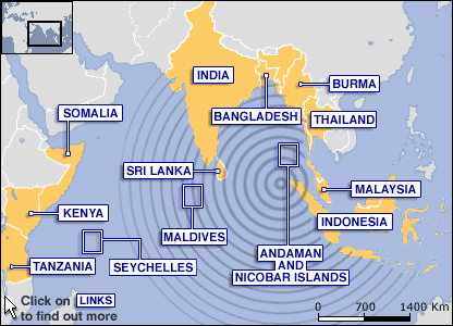
- Map
of Wave Travel Time (NGDC-NOAA). Also has a world
map showing
how the tsunamis propagated around the world, and a wave
elevation (height) map.
- Satellite
images Show Tsunami Destruction of Lhoknga, Indonesia (SpaceRef.com
/ Goddard Space Flight Center).
- Tsunami Media Gallery (DigitalGlobe).
Photographs and satellite imagery, with references to regions.
- Tsunami
Interactive Map (Time). Map, graphics, and imagery of the tsunami
and aftermath.
- Tsunami
Inundation Maps (National Tsunami Hazard Mitigation Program
Center for Tsunami Inundation Mapping Efforts). See maps showing the extent of
flood waters from the tsunamis.
- Satellite
Images by CRISP, Singapore (IKONOS
images/CNES (SPOT images).
- http://www.asiantsunamivideos.com/.
Independent site with a series of videos on the tsunamis. Has extreme
amount of traffic but also has mirror sites to assist. Different
browsers may act differently when downloading.
 Relief Efforts and Country
Contacts Relief Efforts and Country
Contacts
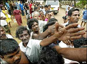
- World
Comes to Aid Tsunami Victims. The aftermath
of the disaster will continue to haunt the Indian Ocean
community, as well as effect the world for years to come.
International reaction has been rapid in sending
help to the region, with pledges of continued support in the future.
- Emergency
hotline numbers to countries.
-
Red Cross Victims Database (Red
Cross). Online database to assist family members
to track down lost loved ones.
Lists of Relief Organizations  Selected List of Major Organizations Selected List of Major Organizations
How to Contact Countries for Information, Assistance Finding Relations
- If you are trying to reach one of these countries
for information, call:
- India: +91
11 2309 3054
- Thailand: +66
2643 5262 and 2643 5000
- Sri
Lanka (residents): +94
11 536 1938
- Sri Lanka
(tourists): +94 11
243 7061
- Maldives:
+44 20 7224 2149
- Seychelles: +248
321 676.
- Also try
the U.S. foreign
embassy list for your country.
- Make
Appeals to Countries (CNN).
If you are looking for someone, you can send an appeal. This is a service
offerred by CNN to assist you in searching for relations. Also
links to responses from "found" individuals.
Tsunami Science General & Brief
How does this event affect the entire world?
See a page of maps and charts that show the extent
of the tsunami's reach to all oceans of the world (West Coast/Alaska
Tsunami Warning Center).
It is amazing!
Science, Research, & In-Depth
- For Maps and GIS, Click
here.
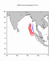
- Sumatra-Andaman
Islands Earthquake and Indian Ocean Tsunamis, December 26,
2004 EQ Net resources page on
the event.
- Northern
Sumatra Earthquake, March 28, 2005 EQ Net.
- About Tsunamis
Page (West Coast & Alaska Tsunami Warning Center (NOAA).
Very good list of resources on all aspects of tsunamis.
- Tsunami
Research Program (NOAA, Pacific Marine Environmental Laboratory).
Research, mapping, models, and all sorts of information. Also
has links to many relevant websites. One page of direct interest
is:
- Data
Sets on the Indonesian Earthquake and Tsunami (NOAA).
The most complete set of links to compiled data from
sources and agencies around the world. Includes seismic
and wave data, maps, tables, GIS, videos, and to photographic
and satellite imagery. Also provides links to most of
the prominent research centers worldwide.
- Tsunami!
(Univ. of Washington, Dept.
of Earth and Space Sciences). Scientific information and
descriptions of tsunamis, including, what causes them, how they
travel, what they can do. Good all-round coverage, including
additional information, such as:
- Tsunami
Information Links (USGS Earthquake Hazards Program). One
of the most complete sites for resources on tsunamis, including
links to warning systems. Resources include:
- National
Tsunami Mitigation Program (PMEL/NOAA). Links to specific
agencies and organizations, data and science sites.
- Tsunami
Data - NOAA Natl. Geophysical Data Center
- Tsunamis -
The Why Files
- Tsunami
FAQ - International Tsunami Information Center
Tsunami
Awareness & Preparedness Tsunami Warning Centers Disaster Preparation  Earthquakes & Seismic
Activity Earthquakes & Seismic
Activity
|

